Rotorua sits on the southern margin of the Rotorua Caldera, a geological setting that produces sharp transitions in ground stiffness across short distances. The warm, sulphur-rich environment and deep volcanic ash deposits create a seismic response that differs markedly from the alluvial basins of Canterbury or the greywacke hill sites of Wellington. When a project triggers a site-specific hazard assessment under NZS 1170.5, a seismic microzonation study becomes essential. We run the field campaigns and laboratory testing that feed directly into the ground model, measuring shear-wave velocity profiles and classifying materials so the response spectra reflect actual subsurface conditions. The work often ties into broader liquefaction screening where the water table is high near the lakefront, and we cross-check results with seismic refraction lines on pumice-rich terraces where MASW alone can be ambiguous.
Lateral variability in the Rotorua Caldera means site class can change within 50 metres: microzonation captures that or you miss the hazard.
Technical details of the service in Rotorua
Critical ground factors in Rotorua
The risk profile varies sharply between the caldera rim suburbs and the lakefront basin. Sites in Glenholme or Springfield overlying the Mamaku Ignimbrite produce low amplification and short-period shaking, while the sedimentary trough beneath Victoria and the lakefront tourist precinct amplifies long-period energy and extends shaking duration significantly. The geothermal gradient adds a complicating factor: warm ground temperatures alter pore-fluid viscosity and can suppress excess pore pressure generation in some silts, a mechanism not captured by standard liquefaction triggering curves. Ignoring these local effects means a building designed for uniform Site Class C could sit on a de facto Class D or E lens without the corresponding ductility demand in the lateral system. Microzonation maps the boundaries so the design basis is defendable at consent review.
Our services
The microzonation workflow combines field geophysics, targeted drilling, and dynamic laboratory testing. We handle the full chain from array layout to GIS-ready hazard layers.
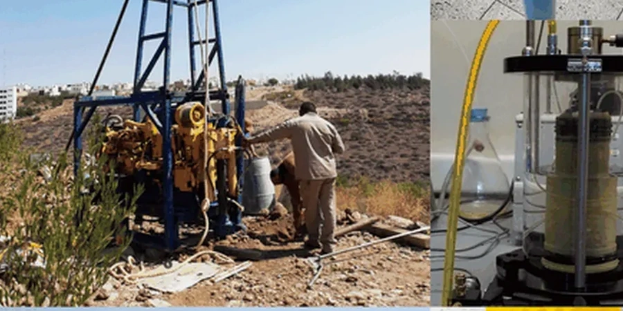
Multi-Method Geophysical Profiling
MASW arrays with 24-channel acquisition, downhole shear-wave logging in cased boreholes, and seismic refraction lines on ignimbrite terrain. We deliver Vs30 maps, Vs profiles with depth, and site class boundaries compliant with NZS 1170.5.
Dynamic Laboratory Testing for Site Response
Resonant column and cyclic triaxial tests on undisturbed volcanic soils to define modulus reduction and damping curves. Bender element measurements for small-strain shear modulus, calibrated to the field Vs profiles from the same borehole.
Questions and answers
When does Rotorua Lakes Council require a seismic microzonation study?
Microzonation is typically triggered for subdivisions of more than three lots on variable ground, for Importance Level 3 and 4 buildings, or when a geotechnical investigation identifies site class boundaries within the project footprint that could change the design hazard. Council may also request it for developments on the lake sediment fringe where long-period amplification is a known concern.
What makes Rotorua's seismic response different from other North Island cities?
The combination of the Rotorua Caldera structure, thick unwelded pyroclastic deposits, shallow geothermal heat, and a high water table near the lake produces amplification patterns and liquefaction susceptibility that do not match the standard basin models applied in Hamilton or Tauranga. Site-specific measurement is necessary because generic NZS 1170.5 site factors may not be conservative.
How much does a seismic microzonation study cost in Rotorua?
Cost depends on area size, number of geophysical lines, and laboratory testing scope. Small-site studies for individual building lots start around NZ$6,030, while multi-hectare subdivision mapping with full dynamic lab programs can reach NZ$32,120. We quote after reviewing the site geology and the council requirements.
What deliverables do we receive from a microzonation study?
You receive a geotechnical report with site class maps, Vs30 and fundamental period maps, representative shear-wave velocity profiles, amplification factor contours, and GIS layers for direct input into structural models. All data is referenced to the NZGD2000 coordinate system and tied to the NZS 1170.5 framework.