Rotorua sits at roughly 280 metres above sea level, right on the southern shore of Lake Rotorua, where the geothermal gradient can shift shallow ground temperature by several degrees across just a hundred metres of section. That quirk alone makes surface assumptions risky. An exploratory test pit opened on a Taupo pumice alluvium terrace can look completely different from one dug into the hydrothermal alteration clays nearer to Whakarewarewa. We run exploratory test pit programmes across Rotorua so builders and geotechnical engineers get a direct, daylight view of the soil profile before committing to foundation design. With NZS 3404:1997 and the NZGS soil description guidelines shaping every log, the goal is a clear answer to one question: what is actually under the grass. When the pits hit buried topsoil or a lens of loose rhyolitic ash, the SPT drilling crew can step in to carry the investigation deeper, but the pit still gives the most honest first look at the top two to three metres.
A single test pit on a Rotorua pumice terrace can reveal more about site drainage and fill history than three distant boreholes combined.
Technical details of the service in Rotorua
Critical ground factors in Rotorua
Between the Ngapuna industrial flats and the elevated residential streets of Springfield, Rotorua’s near-surface geology shifts from loose lacustrine sands to stiff, sometimes swelling, hydrothermally altered tuffs. We have pulled exploratory test pit logs where one side of a gully shows free-draining pumice gravel and the other, barely sixty metres away, exposes a sticky grey clay that holds water for days. That kind of transition matters when you are placing a lightly loaded slab-on-grade: differential movement will find the boundary between two soil types faster than any calculation. The pit lets the engineer trace that boundary visually and decide whether a uniform bearing layer exists or whether ground improvement, maybe vibrocompaction columns, should be considered. In geothermal zones, an exploratory test pit also reveals shallow steam channels or sinter deposits that a borehole might miss entirely. Skipping this step on a variable Rotorua section can turn a straightforward foundation into a long-term settlement problem.
Our services
We keep the scope practical: every exploratory test pit programme in Rotorua comes with machine excavation, a competent person on site for safety oversight, and detailed logging that feeds straight into the geotechnical report. Additional field testing can be integrated on the same day.
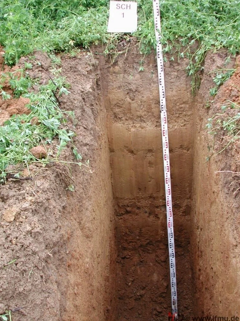
Test pit excavation and logging
Machine-dug pits to a target depth of up to 4 metres, stepped and battered to NZS 4203, with face logging, photography, bulk sampling, and groundwater monitoring carried out by an experienced engineering geologist.
In-situ density and strength testing
Sand cone density tests and pocket penetrometer or hand vane shear readings taken directly on the pit floor or sidewalls, giving immediate data for bearing capacity checks and compaction verification.
Questions and answers
What does an exploratory test pit in Rotorua typically cost?
For a standard programme of two or three pits down to about 3 metres, including machine hire, traffic management where needed, and full logging, the range usually sits between NZ$930 and NZ$1,220 plus GST. The final figure depends on access, ground conditions, and whether specialised sampling such as block samples is required.
How deep can you go with a test pit in Rotorua’s volcanic soils?
Most machine-dug pits reach 3.5 to 4.0 metres before the bucket geometry and safety battering become limiting. In loose pumice sands or hydrothermally altered clays the sides can ravel, so we step the excavation or use a trench box if greater depth is essential. Beyond that, a borehole becomes the safer option.
Is a test pit enough to confirm foundation bearing capacity?
It provides strong observational evidence for shallow foundations. When the pit exposes a competent ignimbrite or dense pumice gravel, a pocket penetrometer profile combined with a bulk sample for lab classification often satisfies the bearing check. Where soils are variable or the structural load is high, we supplement the pit data with SPT or CPT soundings.
How do you manage groundwater in a Rotorua test pit?
We measure the seepage level as soon as the target depth is reached and again after a stabilisation period, typically 20 to 30 minutes. In high-groundwater areas near the lake edge, a sump and pump may be needed to keep the pit floor dry enough for logging. The observed inflow rate itself becomes a useful drainage parameter for the designer.