Rotorua sits inside an active caldera that last erupted around 240,000 years ago, and the ground here tells that story everywhere you look. The 2010 Darfield earthquake sequence, though centred in Canterbury, reignited serious conversations among Rotorua engineers about how local pumiceous ash soils and weak rhyolite tuff behave under cyclic loading. In our experience, a desktop review is never enough when you are cutting a bench into the hillside above Lake Rotorua or widening a road batter through the Mamaku plateau. We combine NZGS guideline-based seismic microzonation considerations with detailed field mapping because the weathered ignimbrite profiles here can lose 60% of their strength when saturated. This city’s geothermal activity also means some slopes sit on ground that has been hydrothermally altered for centuries, and that changes everything about the factor of safety you can realistically achieve.
Weathered ignimbrite in Rotorua can lose over half its peak friction angle when pore pressures rise during prolonged rain.
Technical details of the service in Rotorua
Critical ground factors in Rotorua
Rotorua’s urban footprint has expanded steadily since the 1950s, pushing subdivisions into steeper caldera rim country and onto lake terraces that were never properly characterised before the Resource Management Act raised the bar. We keep seeing the same legacy issue: 1970s-era house cuts with near-vertical faces in pumice that have been slowly notching back for decades. A big storm in February 2018 triggered dozens of small slips around the Kawaha Point and Ngongotaha areas, and that was the wake-up call that prompted Council to request slope stability assessments for more building consent applications. The risk is not just the visible scarp; it is the tension cracks that open 5 metres behind the crest after a dry summer and then fill with water during an ex-tropical cyclone. Once that water column drives the effective stress to zero along a closed joint set, the whole block can move in seconds. Our reports quantify this with a probabilistic sensitivity analysis, showing how the probability of failure shifts with a 10% increase in pore pressure, so the client can decide on drainage or setback measures with their eyes open.
Our services
We structure our Rotorua slope stability work in two phases that match how contractors and architects actually plan their programmes:
Factual and Interpretative Stability Reports
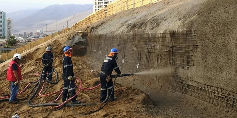
We start with a walkover survey to map tension cracks, seeps, and vegetation indicators, then drill inclined boreholes to pick up the slip surface. The report includes a geomorphological map, laboratory test results for shear strength (direct shear and ring shear on pumice clays), and both limit equilibrium and finite element sections. We deliver a clear factor of safety under static, seismic, and rapid drawdown conditions, plus recommendations for toe weighting, drainage, or geo-grid reinforcement if the numbers are too tight.
Construction Support and Monitoring
Once the remediation design is settled, we put in inclinometer casings and survey prisms to track movement during bulk earthworks—especially critical when cutting near existing homes on the lake side of Kawaha Point. Our team sets up automated rain gauge and piezometer alerts so the contractor knows when a 48-hour rainfall threshold is approaching and can pause or cover exposed batters. We also do post-construction audits to confirm that as-built grades and drainage match the design assumptions, which helps with Council sign-off and long-term liability management.
Questions and answers
What triggers a slope stability assessment in Rotorua under the current Building Code?
The Council will typically request one when your site is on land steeper than 15 degrees, within 50 metres of a mapped fault, or inside a known geothermal or erosion hazard zone. The assessment must demonstrate compliance with NZGS guidelines and NZS 3604 for residential cuts, or NZS 3404 for larger earthworks.
How much does a slope stability analysis cost for a typical Rotorua residential section?
For a standard residential cut with one or two boreholes and an interpretative report, the fee usually falls between NZ$1,800 and NZ$8,020. The final figure depends on access for the drill rig, the depth to competent rock, and whether we need to install piezometers for seasonal monitoring before we can finalise the design.
Can you reuse the same investigation for a retaining wall consent?
Often yes, but it depends on whether the original boreholes are deep enough to satisfy the retaining wall’s global stability requirements. If the wall is over 1.5 metres or supports a surcharge, we may need to extend the investigation and run additional direct shear tests on the backfill and foundation soils to get the interface friction angles right.
How do you handle the geothermal alteration in Tikitere and Sulphur Point?
Hydrothermally altered soils are a different beast. We use Atterberg and X-ray diffraction testing to identify smectite and kaolinite clays that can swell or lose shear strength when disturbed. Our analysis then applies a lower bound effective friction angle, usually around 18 to 22 degrees, and we always specify deeper subsurface drainage to keep the altered zone as dry as possible.